Featured Itinerary – Big Slough Auto Tour at Brazoria National Wildlife Refuge
U.S. Fish & Wildlife Service
Welcomes you to the Big Slough Auto Tour at Brazoria National Wildlife Refuge
Brazoria National Wildlife Refuge
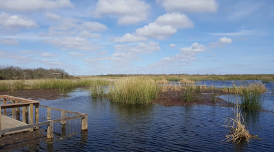
There is parking at each tour stop so you can pull off to enjoy it. This 7-1/2 mile loop usually takes about 1-1/2 hours to drive. On this auto tour you will see managed wetland areas and the wide variety of wildlife supported by them. Throughout the tour, look skyward periodically. You may see refuge residents such as red-tailed hawks, northern harriers, and vultures.
STOP #1 – Discovery Center and Information Pavilion
The islands in the parking lot contain many native plants from across Texas. Behind the pavilion lies the butterfly garden and boardwalk. The garden is designed to attract some of the 110 species that have been recorded in Brazoria County. The water beneath the boardwalk is part of the Big Slough. It’s excellent habitat for herons, wading birds, and migratory waterfowl.
STOP #2 – Big Slough at Picnic Shelter
The Big Slough is a 20-mile freshwater lifeline through the prairie and marsh area that surrounds you. A slough is an extinct alluvial stream with slow moving water. You’ll come near Big Slough several times during the tour.
STOP #3 – Olney Pond
Olney Pond is a managed freshwater wetland. It grows stands of millet that attract and support thousands of snow geese and ducks. Water flows into the pond through a complex system of ditches and water control structures, used to hold and release water. Ditches along the road contain thousands of organisms, which provide large quantities of protein essential in the diets of ducks and shorebirds.
STOP #4 – Crosstrails Area-Fresh Water Marsh
Lots of different species feed and coexist here such as blue-winged teal, northern shovelers, and mottled ducks. You’ll see shorebirds like black-necked stilts and yellowlegs. Wading birds such as ibis and snowy egrets also feed here. On the other side of the road, you’ll see salt marsh. So, you are sitting between two different habitats existing side by side.
STOP #5 – Salt Marsh Observation Deck
Almost all marine organisms owe their existence to areas fed by both salty and fresh water. These “estuaries” are among the most fertile areas on earth. Estuaries are nurseries for young shrimp, crabs, crustaceans, and fish. Stands of smooth cordgrass serve as home to snails, clams, and crabs. Bird residents include rails, marsh wrens, mottled ducks, blue-winged teal, bitterns, herons, and red-winged blackbirds. Large areas of the Gulf Coast bays, called mud flats, are covered by just a few inches of water at low tides. When the water is high, herons, spoonbills, and cormorants gather here. When the tide is out, the neighborhood changes! The mud flats are exposed and become feeding habitat for shore birds such as willets, long-billed curlews, and long-billed dowitchers.
STOP #6- Fly-In Café at Rogers Pond
Rogers Pond is another managed wetland. It was constructed to collect rainfall and provide freshwater habitat amidst a salty environment. Rogers Pond supports up to 10,000 ducks during the winter, and 10,000 shorebirds during the spring and fall migrations. During the summer, thousands of wading birds such as herons, egrets, and wood storks visit the pond.
STOP #7 – Mosquito Crossing
This is a good place to find out more about Brazoria National Wildlife Refuge and the National Wildlife Refuge System. The Refuge is one of six national wildlife refuges within the same ecosystem region. It is the guardian of precious coastal prairie and a haven to more than 300 bird species. The Refuge protects one of the last remaining significant coastal prairie areas in Texas, with more than 5,000 acres of native bluestem.
STOP #8 – North Side of Crosstrails
The Texas coast is noted for fishing and the Refuge provides several saltwater fishing opportunities. The Bastrop Bayou public fishing area, open 24-hours a day to fishing and crabbing, offers a universally accessible lighted fishing pier with lights that attract fish. It also has bank fishing pull-offs and a restroom. The Clay Banks public fishing area, open for daylight use only, has access on Bastrop Bayou for bank fishing. The Salt Lake Public Fishing area provides handicap-accessible bank fishing and a non-motorized boat launch.
STOP #9 – Teal Pond
Teal Pond is a showcase for wintering waterfowl. Under the right conditions, the pond will grow stands of millet. Snow geese need to eat grit (gravel) to aid digestion and are attracted to the west shoreline where a grit pad is located. The Refuge and the rest of the Texas Gulf Coast are the primary wintering areas for most of the Central Flyway waterfowl. Flyways are the routes waterfowl follow from their northern nesting grounds to their southern wintering areas and back. Snow geese, along with smaller populations of Canada and white-fronted geese, usually reach peak numbers of 50,000 on the Refuge during December and January.
STOP #10 – Alligator Watch
This part of Big Slough is an alligator magnet because it is one of the last areas to dry up in a drought. The once endangered American alligator is the largest of all members of the crocodile family in North America. It has a large body with thick limbs, a broad head, and an extremely muscular tail to propel itself powerfully through water.
STOP #11 – Teal Pond Viewing Platform
The trail and platform here are easily accessible. . You may see hawks, harriers, kestrels, and white-tailed kites. Both Teal and Olney Ponds are managed for similar reasons. Good water levels are kept during the winter for geese and ducks. They are drawn down in the spring for shorebird migration. Then the ponds are drained in the summer for millet germination. In the fall, the Refuge starts to re-flood the ponds for shorebird migration. Filling continues in the late fall for the ducks and geese. Then the cycle starts over again!
STOP #12 – Big Slough Deep Water
Ruddy ducks and grebes are often found in the large opening in Big Slough where the water is deep. As you see birds feeding, notice their bills are different. Shovelers use their large bills to strain the water for aquatic organisms. The gadwalls and pintails tip forward to feed on the bottom of shallow pools. Ruddy ducks dive into the deep water to feed on bottom plants. The long up-curved bill of avocets helps sweep and probe the mud for crustaceans. Ibises and spoonbills have their own unique bills for probing. Spoonbills feed on small aquatic creatures that they catch by wading as they swing their big, opened bills from side to side. American pelicans feed by scooping up fish in their bills as they swim on the surface.
STOP #13 – Big Slough Turn to the Platform
In 1857, a shipping canal was created from Galveston to the Brazos River, which was used to transport people and goods in and out of the Brazoria area. In 1913, the canal was modernized but was later abandoned for the present-day Gulf Intracoastal Waterway.
STOP #14 – Refuge Management Practices
About 62 percent of the Refuge is wetlands. Saltwater and freshwater marshes and prairie potholes are examples of wetlands. Coastal wetlands are important because marshes provide habitat and a refueling place for migrating shorebirds and waterfowl. The broad fringe of plants absorbs the energy of waves to stop shoreline erosion. The fine sediments and roots in the wetlands absorb or detoxify chemical contaminants. They are also great places to enjoy the wonderful combination of sun, sky, water, plants, and wildlife.
More than a million acres of Texas coastal wetlands have been lost in the last century. To combat this loss, the Refuge management activities have focused on protecting and enhancing wetlands, restoring former wetlands, and creating new ones.
Water levels are managed through dikes and water control structures, and provide feeding and resting areas for waterfowl. Herbicides control unwanted plants that compete with native plants. Removing exotic plants helps maintain natural diversity and renews native plants. Prescribed or controlled burns reduce plant litter, retard brushy plant intrusion, reduce the threat of wildfire, and improve access to the roots for waterfowl.
Safety Tips
- Refuge open sunrise to sunset
- Please do not feed the wildlife
- Pets must be leashed
- Watch for alligators and poisonous snakes
- No firearms permitted
- No off road vehicle use
- Please do not litter
- Fishing in designated areas only
The NWRS is the world’s largest and most unique network of lands and waters set aside specifically for conservation of fish, wildlife, and plants. In 1903, President Theodore Roosevelt established the first refuge, 3-acre Pelican Island Bird Reservation, in Florida. Today the system contains more than 540 units spread over nearly 94 million acres.